


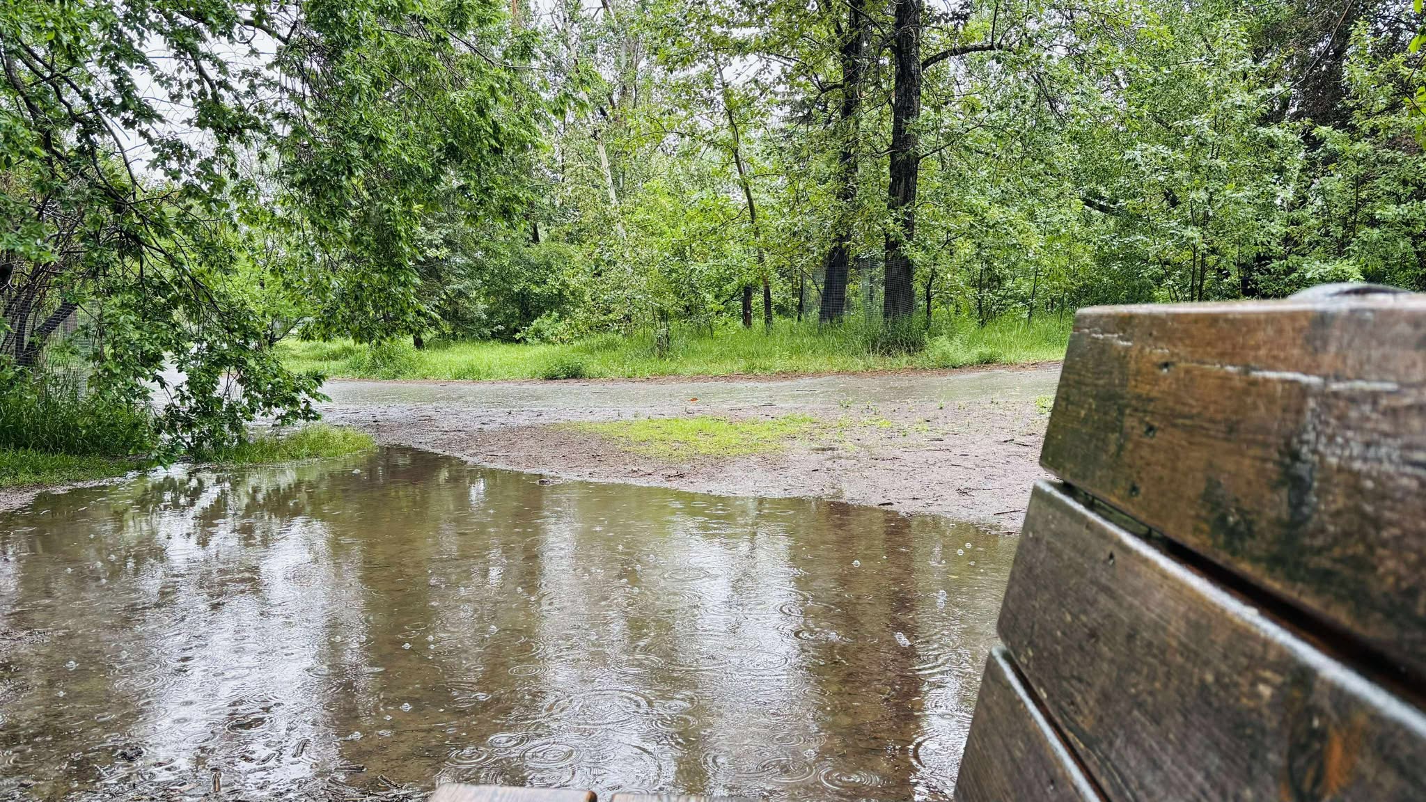
A rainfall warning for the Airdrie area has ended after heavy rain moved across much of Alberta over the weekend, though showers, gusty wind, local smoke and the risk of a thunderstorm remain in the local forecast.
Related Stories:
-
Update: Rainfall warning ends for Airdrie, but showers and local smoke remain in forecast
-
Alberta Parks urges people to avoid non-essential travel to Kananaskis Country
-
Mudslide closes section of Highway 40 between Little Highwood Pass and Elbow Lake Trail
Environment Canada issued a weather summary at 9:09 a.m. Monday, saying periods of heavy rain impacted much of the province over the weekend. Rain was expected to continue over southern Alberta Monday.
The rainfall amounts in the summary were recorded since Friday evening.
Flood warning issued for Bragg Creek area
Rocky View County said the Alberta River Forecast Centre has upgraded the Elbow River advisory from a Flood Watch to a Flood Warning due to high river flows near Bragg Creek.
The county said Alberta Agriculture and Irrigation has begun operating the Springbank Off-Stream Reservoir, also known as SR1, to help reduce downstream flood risk.
According to the county, SR1 temporarily diverts and stores flood water, helping reduce peak flows into the Glenmore Reservoir.
As a precaution, the county said it is preparing to close parts of Springbank Road until further notice. Residents and motorists are being asked to use an alternate route, allow extra travel time and obey all road closure signs.
The county also warned that residents upstream of Bragg Creek may have access roads or driveways cut off.
Motorists are being reminded not to drive through flooded areas, while hikers and cyclists are being urged to use caution, including on familiar trails in Kananaskis, where conditions are described as extremely saturated, muddy and potentially slippery.
The county is also asking people to stay away from the river and river banks.
Rainfall totals reported across Alberta
Official Environment and Climate Change Canada rainfall reports as of 7 a.m. Monday included 79 millimetres at Waterton Park Gate, 68 millimetres at Stavely, 67 millimetres at Camrose, 61 millimetres at Campsie and 60 millimetres at Villeneuve.
Other official totals included 59 millimetres at Barrhead, 58 millimetres at Coronation, 57 millimetres in Edmonton, 54 millimetres at Elk Island National Park, 52 millimetres at Beaver Mines and 51 millimetres in both Sundre and Calgary.
Banff, Bow Valley and Carway each recorded 45 millimetres. Lacombe recorded 43 millimetres and Red Deer recorded 41 millimetres.
Third-party rainfall reports were higher in some areas, with Kananaskis Village listed at 102 millimetres.
Other third-party reports included 76 millimetres in Whitecourt, 65 millimetres in Beiseker, 59 millimetres in Entwistle, 58 millimetres in Brazeau County, 51 millimetres in Lac Ste. Anne County, 50 millimetres in Diamond Valley, 49 millimetres in Rocky Mountain House, 48 millimetres in Sylvan Lake, 46 millimetres in Blackie, 43 millimetres in Wildwood and 40 millimetres in Redwater.
Environment Canada said the summary may contain preliminary or unofficial information and does not constitute a complete or final report.
Kananaskis under State of Local Emergency
In Kananaskis Country, officials have declared a State of Local Emergency due to ongoing rainfall and localized flooding affecting road access and several recreation areas.
Alberta Parks said some road access remains limited in parts of Kananaskis Country, and officials are working to establish road access for people currently unable to leave the area.
Visitors already in the area are being asked to remain where they are if it is safe to do so.
William Watson Lodge and the Peter Lougheed Discovery Centre are available as temporary shelter locations for those who require a safe, dry place to stay.
Alberta Parks is also asking visitors to postpone non-essential travel until conditions improve.
The notice said impacted reservations will be automatically cancelled and refunded.
Emergency teams continue to co-ordinate response efforts, monitor infrastructure, support campground operations and maintain road closures where needed.
Showers, smoke remain in Airdrie forecast
In Airdrie, showers, local smoke and a thunderstorm risk remain in the forecast.
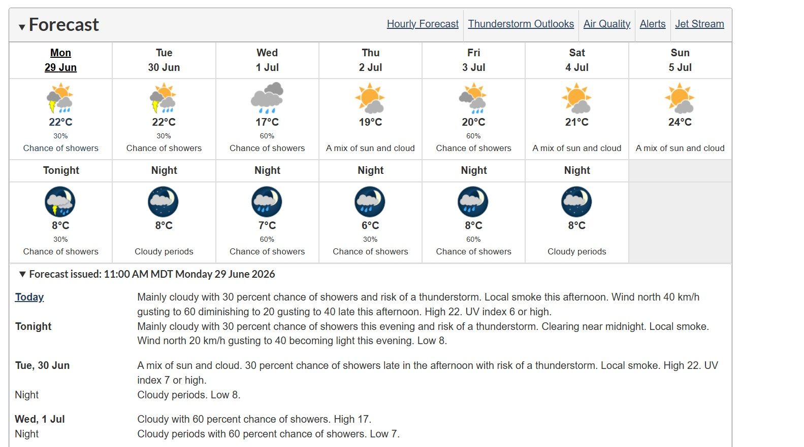
Environment Canada is calling for mainly cloudy skies Monday, with a 30 per cent chance of showers and the risk of a thunderstorm. Local smoke is expected in the afternoon.
North winds of 40 km/h, gusting to 60, are expected to diminish to 20 km/h, gusting to 40, late in the afternoon.
The daytime high is forecast at 22 C.
Monday night is expected to remain mainly cloudy, with a 30 per cent chance of showers in the evening and the risk of a thunderstorm.
Skies are expected to clear near midnight, with local smoke continuing and an overnight low of 8 C.
Tuesday is forecast to bring a mix of sun and cloud, local smoke and a 30 per cent chance of showers late in the afternoon, along with the risk of a thunderstorm.
The high Tuesday is expected to reach 22 C.
Canada Day forecast includes showers
Canada Day is forecast to be cloudy in Airdrie, with a 60 per cent chance of showers and a high of 17 C.
Cloudy periods and a 60 per cent chance of showers are expected Wednesday night, with a low of 7 C.
Thursday is forecast to bring a mix of sun and cloud and a high of 19 C.
Friday is expected to bring a mix of sun and cloud, a 60 per cent chance of showers and a high of 20 C.
Temperatures are forecast to rise later in the week, with highs of 21 C Saturday and 24 C Sunday.
Airdrie’s seasonal normals are a high of 21 C and a low of 8 C.
Listen live to Air 106.1 FM for local news, weather, traffic and community updates throughout the day. Stream us anytime through the DiscoverAirdrie app or online.


 Wed, Jul 1, 5:00 AM
 Full-time, Permanent, Communications/Media, Sales